Section A: Mexican Boarder
to Warner Springs
|
Over the Laguna Mountain range and through
Anza-Borrego Desert State Park.
|
|
|
7/7/98 Southern terminus of the PCT, just after dusk. Photo by Tim Hagertty, who brought me to the trailhead. Thanks, Tim!
|
|
|
7/8/98 Somewhere just a couple of miles north of Campo.
|
|
|
7/9/98 Lake Morena, seen while going away the next morning after camping nearby.
|
|
|
7/9/98 Interstate 8, seen just after having crossed it, looking north.
|
|
|
7/10/98 The first large pine trees as one ascends toward the Laguna Mts.
|
|
|
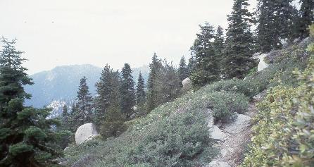
7/10/98 This and the next two are just pretty views.
|
|
|
7/10/98
|
|
|
7/10/98
|
|
|
7/10/98 A few miles north of Pioneer Mail Trailhead, evening.
Waterless camp, as I didn't feel like taking the very nasty water from the cattle
trough at Pioneer Mail Trailhead. I had to walk dehydrated the next day about
10 miles to Cuyamaca Resevoir, where I discovered that my PUR water filter
was clogged beyond all help.
|
|
|
7/11/98 After getting water down Rodriguez Spur Truck Trail,
looking toward the north at the San Felipe Hills on the right.
|
|
|
7/11/98 Just past Rodriguez Spur Truck Trail I encountered this recent burn -
in fact, locals told me later it had burned just the week before.
|
|
|
7/11/98 Another view of the burn area.
|
|
|
7/11/98 Another view of the burn area.
|
|
|
7/12/98 While hitching a ride up Hwy. 78 to Julian, I took a picture
of my reflection in one of those wide angle mirrors in someone's driveway.I was
heading to Julian to get iodine, since my filter was useless, and drinking straight
from San Felipe Creek didn't appeal to me!
|
|
|
7/12/98 Back up on the trail after visiting Julian, this view shows
the PCT stretching off and down toward the San Felipe Valley. The next day I
road-walked the length of the San Felipe Hills to Barrel Spring. Reason was that it
was hot as hell -- it must've been 110 degrees minimum in the middle of the day --
and I didn't feel like taking too big a risk with dehydration and heat
exhaustion walking the 20 waterless miles through the hills.
|
|
|
7/14/98 View approaching Warner Springs. The white dome of the Palomar
Observatory is on the ridgetop, but can't be seen in the picture as it turned out.
|
|
|
7/12/98 Another view approaching Warner Springs.
|
Section B: Warner Springs
to San Gorgonio Pass
|
Over the San Jacinto Mountains.
|
|
|
7/18/98 This is a view of the trail down to Live Oak Spring, map B6.
I camped there two nights because of bad blisters. This was the only time I've ever had blisters, and it was
because I was trying something new: lightweight boots and thin, nylon socks.
When I got to Idyllwild I promptly bought a pair of leather boots and a couple
of pairs of thick socks.
|
|
|
7/18/98 This is a siesta spot. In July in these parts the noonday sun was
too hot to walk in. I generally hunkered down in the shade for about three hours around the middle of the day.
|
|
|
7/18/98 This was just a charming bit of trail.
|
|
|
7/18/98 View looking east off the ridge toward Palm Springs. Too bad I overexposed
the desert floor. Then again, some people say that Palm Springs is already overexposed.
|
|
|
7/18/98 I believe this is a view of Apache Peak from the south,
from Spitler Peak, both on the north end of map B7. If I'm wrong, someone please tell me.
|
|
|
7/18/98 This and the next two are views along the ridgeline approaching
Saddle Junction above Idyllwild.
|
|
|
7/18/98
|
|
|
7/18/98
|
|
|
7/21/98 A view along the side trail up San Jacinto Peak.
|
|
|
7/21/98 Near the summit of San Jacinto Peak - Polly Peak.
|
|
|
7/21/98 Me on San Jacinto Peak (10,804 ft.).
|
|
|
7/21/98 The afternoon view descending toward
Interstate 10/San Gorgonio Pass.
|
|
|
7/21/98 View over afternoon fog northward showing
San Gorgonio Mountain, seen from near the top of map B10.
|
|
|
7/22/98 Morning view of Interstate 10, looking northeast.
|
|
|
7/22/98 A view of Snow Canyon, map B11. This is descending
to Interstate 10 at Gorgonio Pass. The new water fountain is down there!
|
Section C: San Gorgonio Pass
to Interstate 15
|
The San Bernardino Mountains.
|
|
|
7/22/98 Sign says I've come 217 miles. Wind generators just north of I-10.
|
|
|
7/23/98 Mesa Wind Station, morning.
|
|
|
7/23/98 Self Portrait, between Whitewater River and East Fork Mission Creek.
San Gorgonio Mountains in the background.
|
|
|
7/24/98 View walking up North Fork, Mission Creek.
|
|
|
7/24/98 Up in the San Bernardino Mountains at last, this is a view of
what looks a lot like smog drifting up from LA.
|
|
|
7/24/98 Mt. San Jacinto seen from the San Bernardinos, looking south.
|
|
|
7/24/98 Another view of Mt. San Jacinto from north of it.
|
|
|
7/24/98 San Gorgonio Mountain (11,499 ft.), the snow-capped one, to the west of the trail.
The PCT doesn't actually go over it.
|
|
|
7/25/98 That bloomin' cactus!
|
|
|
7/25/98 Attempt at a self portrait that looks like a candid shot of me just walkin' along.
|
|
|
7/25/98 Baldwin lake, approaching it from the south.
|
|
|
7/25/98 Baldwin lake.
|
|
|
7/28/98 Big Bear Lake, after spending three nights in Big Bear City.
|
|
|
7/28/98 Big Bear Lake, showing the solar observatory.
|
|
|
7/28/98 Another picture of Big Bear Lake, showing the solar observatory.
|
|
|
7/29/98 At the bottom of Deep Creek canyon, here's the Mojave River
Forks Reservoir dam, which the guidebooks describes as "overkill." Damn straight.
|
|
|
7/30/98 Silverwood Lake, an artificial reservoir.
|
|
|
7/31/98 Badlands above Cajon Canyon, looking toward Interstate 15.
The guidebook describes it thus: "The Pliocene sediments here have eroded from the infant
San Gabriel Mountains, then shifted east, relatively speaking, along the San Andreas
Fault, which now cuts through Cajon Canyon, below. Because these sediments have
been removed from their source of rejuvenating alluvium, stream flow has easily incised
their once gently sloping surfaces into a dramatic series of razorback ridges."
|
Section D: Interstate 15
to Agua Dulce
|
The San Gabriel Mountains.
|
|
|
8/1/98 The San Andreas Rift Zone, approaching it from the east.
View looks northwest.
|
|
|
8/1/98 It was a long 20 miles from I-15 up to Guffy Campground, 5,000 ft. higher.
No water along the way, so by the time I reached the spring at Guffy, it tasted like
heaven. A picture near the top. What is that on the left?
|
|
|
8/3/98 Spent two nights at Guffy Campground, with the day in between
spent descending to Wrightwood and hauling a resupplied pack back up. This is
our friend Ursus at Little Jimmy Campground.
The one-and-only bear I saw in '98.
|
|
|
8/4/98 Yours truly on top of Mt. Baden-Powell (9,399 ft.).
|
|
|
8/4/98 Not sure where this is, but it's a nice view.
|
|
|
8/4/98 Wild bighorn sheep. These are the times a telephoto would have
been great to have. But I only had a few seconds to get the shot.
|
|
|
8/6/98 Another nice view, but I don't remember exactly where it is.
|
|
|
8/??98 Probably somewhere near Soledad Canyon Road, or perhaps near North Fork
Saddle Ranger Station?
|
|
|
8/9/98 Vasquez Rocks. The straight line in the distance is the
Antelope Valley Freeway.
|
|
|
8/9/98 Vasquez Rocks. End of this summer's section hike.
|